

Important facts you need to know about the city of “Ibadan” in Nigeria
(Yoruba: Ìbàdàn ) is the capital and most populous city of Oyo State, Nigeria . With a population of over 6 million, it is the third most populous city in Nigeria after Lagos and Kano ; it is the country’s largest city by geographical area . At the time of Nigeria’s independence in 1960, Ibadan was the largest and most populous city in the country, and the second most populous in Africa behind Cairo.
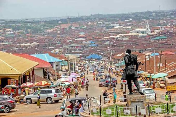
Ibadan is located in south-western Nigeria, 128 kilometres (80 mi) inland northeast of Lagos and 530 kilometres (330 mi) southwest of Abuja , the federal capital, and is a prominent transit point between the coastal region and the areas in the hinterland of the country. Ibadan had been the centre of administration of the old Western Region since the days of the British colonial rule, and parts of the city’s ancient protective walls still stand to this day. The principal inhabitants of the city are the Yorubas, as well as various communities from other parts of the country.
Ibadan, coined from the phrase “Eba Odan”, which literally means ‘by the edge of the meadow’, came into existence in 1829, during a period of turmoil that characterized Yorubaland at the time. It was in this period that many old Yoruba cities such as old Oyo (Oyo ile), Ijaye and Owu disappeared, and newer ones such as Abeokuta, new Oyo (Oyo atiba) and Ibadan sprang up to replace them. According to local historians, Lagelu founded the city, and was initially intended to be a war camp for warriors coming from Oyo, Ife and Ijebu . As a forest site containing several ranges of hills, varying in elevation from 160 to 275 metres, the location of the camp offered strategic defence opportunities. Moreover, its location at the fringe of the forest (from which the city got its name) promoted its emergence as a marketing centre for tradersIn 1852 the Church Missionary Society sent David and Anna Hinderer to found a mission. They decided to build the mission and a church in Ibadan when they arrived in 1853.
Ibadan thus had initially begun as a military state and remained so until the last decade of the 19th century. The city-state also succeeded in building a large empire from the 1860s to the 1890s which extended over much of northern and eastern Yorubaland. It was appropriately nicknamed idi Ibon or “gun base”, because of its unique military character.
Unlike other Yoruba cities with traditional kingship institutions however, In Ibadan, the warrior class became the rulers of the city as well as the most important economic group. Ibadan grew into an impressive and sprawling urban center so much that by the end of 1829, Ibadan dominated the Yorùbá region militarily, politically and economically . The military sanctuary expanded even further when refugees began arriving in large numbers from northern Oyo following raids by Fulani warriors. After losing the northern portion of their region to the marauding Fulanis , many Oyo indigenes retreated deeper into the Ibadan environs. The Fulani Caliphate attempted to expand further into the southern region of modern-day Nigeria, but was decisively defeated by the armies of Ibadan in 1840, which eventually halted their progress. The colonial period reinforced the position of the city in the Yoruba urban network. After a small boom in rubber business (1901-1913), cocoa became the main produce of the region and attracted European and
Levantine firms, as well as southern and northern traders from Lagos, Ijebu-Ode and Kano among others. The city became a major point of bulk trade. Its central location and accessibility from the capital city of Lagos were major considerations in the choice of Ibadan as the headquarters of the Western Provinces (1939) which ranged from the northernmost areas of Oyo State to Ekeremor, Bomadi and Patani, which were regions transferred from the old Delta province in the Old Western region and later Mid-west to the old Rivers state and later Bayelsa, in the redistricting of Nigeria carried out by the Yakubu Gowon administration shortly before the Nigerian civil war and goods from both the forest and grassland areas.
Ibadan is located in south-western Nigeria in the southeastern part of Oyo State at about 119 kilometres (74 miles) northeast of Lagos and 120 kilometres (75 miles) east of the Nigerian international border with the Republic of Benin. It lies completely within the tropical forest zone but close to the boundary between the forest and the derived savanna. The city ranges in elevation from 150 m in the valley area, to 275 m above sea level on the major north–south ridge which crosses the central part of the city. The city covers a total area of 3,080 square kilometres (1,190 sq mi), the largest in Nigeria after Bauchi.
The city of Ibadan is naturally drained by four rivers with many tributaries: Ona River in the North and West; Ogbere River towards the East; Ogunpa River flowing through the city and Kudeti River in the Central part of the metropolis. Ogunpa River, a third-order stream with a channel length of 12.76 km and a catchment area of 54.92 km 2. Lake Eleyele is located at the northwestern part of the city, while the Osun River and the Asejire Lake bounds the city to the east.
There are eleven (11) Local Governments in Ibadan Metropolitan area consisting of five urban local governments in the city and six semi-urban local governments in the less city. Local governments at present are institutions created by the military governments but recognised by the 1999 constitution and they are the third tiers of government in Nigeria. Local governments Councils consist of the Executive Arm made up of the Executive Chairman, the Vice chairman, the Secretary and the Supervisory Councilors.
Local government areas
1. Ibadan North
2. Ibadan North-East
3. Ibadan North-West
4. Ibadan South-East
5. Ibadan South-West
6. Akinyele
7. Egbeda
8. Ido
9. Lagelu
10. Ona Ara
11. Oluyole
Simply the best from Cometowestafrica.